HOME | Ashland | Bandon | Bend | Brookings | Cannon Beach | Coos Bay | Eugene | Depoe Bay | Florence | Gearhart | Gold Beach | Grants Pass | Hermiston | Jacksonville
Joseph | Klamath Falls | La Pine | Lincoln City | Manzanita | Medford | Newport | Portland | Port Orford | Rockaway | Roseburg | Salem | Seaside | Sisters | Yachats | ALL ...
HOTELS |  VACATION RENTALS |  RV PARKS |  B & B'S |  RESORTS |  WEATHER |  ROAD CAMS |  MAPS |  KAYAKING |  WINERIES |  RAFTING |  LIGHTHOUSES 
Mount St. Helens
Mount St. Helens VolcanoCam

Covered Bridges
:: Harris
:: Hayden
:: Irish Bend
:: Sandy Creek
:: Rock O' the Range
:: Cavitt Creek
:: Horse Creek
:: Milo Academy
:: Neal Lane
:: Pass Creek
:: Rochester
:: Antelope Creek
:: Lost Creek
:: McKee
:: Wimer
:: Grave Creek
:: Belknap
:: Centennial
:: Chambers
:: Coyote Creek
:: Currin
:: Deadwood
:: Dorena
:: Earnest
:: Goodpasture
:: Lake Creek
:: Lowell
:: Mosby Creek
:: Office (Westfir) Bridge
:: Parvin (Lost Creek) Bridge
:: Pengra (Fall Creek) Bridge
:: Stewart
:: Unity
:: Wendling
:: Wildcat Creek (Austa) Bridge
:: Chitwood
:: Drift Creek
:: Fisher School
:: North Fork Yachats
:: Crawfordsville
:: Gilkey
:: Hannah
:: Hoffman
:: Larwood
:: Shimanek
:: Short
:: Weddle
:: Gallon House
:: Stayton-Jordan
:: Cedar Crossing
:: Fourtner
:: Ritner

Weather Forecasts
:: Adams
:: Albany
:: Ashland
:: Astoria
:: Bandon
:: Bend
:: Brookings
:: Chiloquin
:: Dayton
:: Depoe Bay
:: Eugene
:: Florence
:: Fossil
:: Gold Beach
:: Government Camp
:: Glide
:: Hood River
:: Jacksonville
:: Joseph
:: Klamath Falls
:: Lincoln City
:: Mt. Hood
:: Newport
:: Pacific City
:: Paisley
:: Port Orford
:: Portland
:: Roseburg
:: Sunriver
:: Vida
:: Waldport
:: Yachats

Bookmark Us!

Newsletter Signup:


North Fork Yachats Covered Bridge, Lincoln County, Oregon
<< Lincoln County Bridges << Covered Bridge Map All Covered Bridges >>


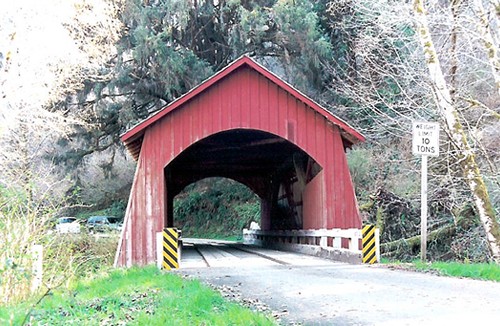
The rustic covered bridge spanning the North Fork of the Yachats cost the county only $1,500 when built in 1938, and was the last covered span constructed by veteran bridge builder Otis Hamer.

Located just seven miles from the salt water of the Pacific Ocean, this trim little bridge is one of the few to escape the "graffiti artists" so common in many other covered bridges.

Since the covered span is the only access for families in the area, the bridge roof was removed to allow a mobile home to cross in the early 1980s.

In 1987, a loaded fuel truck crashed through a weakened approach on the bridge and the accident ruptured a fuel tank. Luckily, no fuel reached the river, and county crews soon repaired damage to the bridge.

The bridge was rehabilitated in 1989 when work crews replaced the trusses and approaches. A new roof and siding were also added.

A dedication in December 1989 officially re-opened the bridge to traffic. The engineer who designed the remodeling stated the bridge, with proper maintenance, should last another 50 years.

The nearby community was established in 1880 as Ocean View, and was changed to Yachats in 1916 in salutation to a local tribe. The name "Yachats," according to the tribe, means "at the foot of the mountain," an appropriate nomenclature for both the bridge and the community.


From Yachats travel approximately 7 miles east on Yachats River Road to N Yachats River Road. At the intersection turn north and travel approximately 1.5 miles.


Covered Bridge Information Courtesy of Covered Bridge Society of Oregon

Privacy < BACK  | HOME > Terms of Service
Contact OregonTravels.com
PO Box 1475
Medford, OR 97501
Office
541-499-4077
Email

SEARCH


Climb with an Accredited Guide Service
Lake Creek Lodge
Seaside vacation Rentals

Orange Torpedo offers unique white water rafting trips on the Rogue, Salmon, Klamath and North Umpqua Rivers

Flying Arrow Resort, Joseph Oregon