HOME | Ashland | Bandon | Bend | Brookings | Cannon Beach | Coos Bay | Eugene | Depoe Bay | Florence | Gearhart | Gold Beach | Grants Pass | Hermiston | Jacksonville
Joseph | Klamath Falls | La Pine | Lincoln City | Manzanita | Medford | Newport | Portland | Port Orford | Rockaway | Roseburg | Salem | Seaside | Sisters | Yachats | ALL ...
HOTELS |  VACATION RENTALS |  RV PARKS |  B & B'S |  RESORTS |  WEATHER |  ROAD CAMS |  MAPS |  KAYAKING |  WINERIES |  RAFTING |  LIGHTHOUSES 
Mount St. Helens
Mount St. Helens VolcanoCam

Covered Bridges
:: Harris
:: Hayden
:: Irish Bend
:: Sandy Creek
:: Rock O' the Range
:: Cavitt Creek
:: Horse Creek
:: Milo Academy
:: Neal Lane
:: Pass Creek
:: Rochester
:: Antelope Creek
:: Lost Creek
:: McKee
:: Wimer
:: Grave Creek
:: Belknap
:: Centennial
:: Chambers
:: Coyote Creek
:: Currin
:: Deadwood
:: Dorena
:: Earnest
:: Goodpasture
:: Lake Creek
:: Lowell
:: Mosby Creek
:: Office (Westfir) Bridge
:: Parvin (Lost Creek) Bridge
:: Pengra (Fall Creek) Bridge
:: Stewart
:: Unity
:: Wendling
:: Wildcat Creek (Austa) Bridge
:: Chitwood
:: Drift Creek
:: Fisher School
:: North Fork Yachats
:: Crawfordsville
:: Gilkey
:: Hannah
:: Hoffman
:: Larwood
:: Shimanek
:: Short
:: Weddle
:: Gallon House
:: Stayton-Jordan
:: Cedar Crossing
:: Fourtner
:: Ritner

Weather Forecasts
:: Adams
:: Albany
:: Ashland
:: Astoria
:: Bandon
:: Bend
:: Brookings
:: Chiloquin
:: Dayton
:: Depoe Bay
:: Eugene
:: Florence
:: Fossil
:: Gold Beach
:: Government Camp
:: Glide
:: Hood River
:: Jacksonville
:: Joseph
:: Klamath Falls
:: Lincoln City
:: Mt. Hood
:: Newport
:: Pacific City
:: Paisley
:: Port Orford
:: Portland
:: Roseburg
:: Sunriver
:: Vida
:: Waldport
:: Yachats

Bookmark Us!

Newsletter Signup:


Larwood (Crabtree Creek) Covered Bridge, Linn County, Oregon
<< Linn County Bridges << Covered Bridge Map All Covered Bridges >>


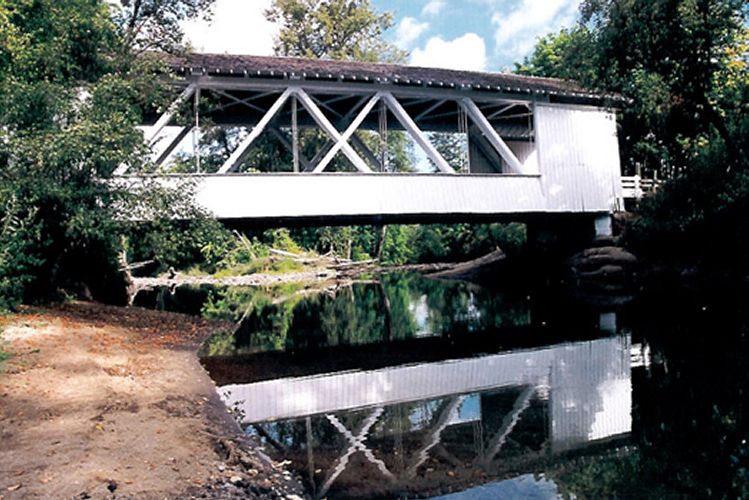
The attractive Larwood Bridge was built to Highway Commission specifications which included a standard 105-foot length, partially exposed trusses, white-wash interior and rounded portals.

In 2002, the bridge was temporarily closed to repair the exposed diagonal timbers in the upstream truss. Water and insect damage had weakened the wooden pieces.

The covered span is located three miles north of Lacomb, next to Larwood Wayside Park. Roaring River, which empties into Crabtree Creek near the bridge, is the only river to flow into a creek, an oddity in U. S. geography that was featured in Ripley's Believe It or Not.

The Larwood community was named for William Larwood, who settled on the banks of Crabtree Creek and Roaring River in 1888. He platted the little town, built a store and blacksmith shop, and operated a post office from 1893 to 1903.

A prior covered bridge was built about this time over Crabtree Creek, and for a while, covered bridges spanned Roaring River and Crabtree Creek just a few feet apart. The town and old covered bridges are gone, but the rebuilt water powered mill and the present covered bridge are reminders of the area's previous activities.

The adjacent park is frequented by fishermen and swimmers.


From I-5 at Albany take Highway 226 (US Route 20) (exit 233) east to Crabtree. From Crabtree travel east on Highway 226 approximately 1 mile to Fish Hatchery Drive. Travel east on Fish Hatchery Road for approximately 6 miles.


Covered Bridge Information Courtesy of Covered Bridge Society of Oregon

Privacy < BACK  | HOME > Terms of Service
Contact OregonTravels.com
PO Box 1475
Medford, OR 97501
Office
541-499-4077
Email

SEARCH


Climb with an Accredited Guide Service
Lake Creek Lodge
Seaside vacation Rentals

Orange Torpedo offers unique white water rafting trips on the Rogue, Salmon, Klamath and North Umpqua Rivers

Flying Arrow Resort, Joseph Oregon