HOME | Ashland | Bandon | Bend | Brookings | Cannon Beach | Coos Bay | Eugene | Depoe Bay | Florence | Gearhart | Gold Beach | Grants Pass | Hermiston | Jacksonville
Joseph | Klamath Falls | La Pine | Lincoln City | Manzanita | Medford | Newport | Portland | Port Orford | Rockaway | Roseburg | Salem | Seaside | Sisters | Yachats | ALL ...
HOTELS |  VACATION RENTALS |  RV PARKS |  B & B'S |  RESORTS |  WEATHER |  ROAD CAMS |  MAPS |  KAYAKING |  WINERIES |  RAFTING |  LIGHTHOUSES 
Mount St. Helens
Mount St. Helens VolcanoCam

Covered Bridges
:: Harris
:: Hayden
:: Irish Bend
:: Sandy Creek
:: Rock O' the Range
:: Cavitt Creek
:: Horse Creek
:: Milo Academy
:: Neal Lane
:: Pass Creek
:: Rochester
:: Antelope Creek
:: Lost Creek
:: McKee
:: Wimer
:: Grave Creek
:: Belknap
:: Centennial
:: Chambers
:: Coyote Creek
:: Currin
:: Deadwood
:: Dorena
:: Earnest
:: Goodpasture
:: Lake Creek
:: Lowell
:: Mosby Creek
:: Office (Westfir) Bridge
:: Parvin (Lost Creek) Bridge
:: Pengra (Fall Creek) Bridge
:: Stewart
:: Unity
:: Wendling
:: Wildcat Creek (Austa) Bridge
:: Chitwood
:: Drift Creek
:: Fisher School
:: North Fork Yachats
:: Crawfordsville
:: Gilkey
:: Hannah
:: Hoffman
:: Larwood
:: Shimanek
:: Short
:: Weddle
:: Gallon House
:: Stayton-Jordan
:: Cedar Crossing
:: Fourtner
:: Ritner

Weather Forecasts
:: Adams
:: Albany
:: Ashland
:: Astoria
:: Bandon
:: Bend
:: Brookings
:: Chiloquin
:: Dayton
:: Depoe Bay
:: Eugene
:: Florence
:: Fossil
:: Gold Beach
:: Government Camp
:: Glide
:: Hood River
:: Jacksonville
:: Joseph
:: Klamath Falls
:: Lincoln City
:: Mt. Hood
:: Newport
:: Pacific City
:: Paisley
:: Port Orford
:: Portland
:: Roseburg
:: Sunriver
:: Vida
:: Waldport
:: Yachats

Bookmark Us!

Newsletter Signup:


Oregon Covered Bridges - Salem Power Canal (Stayton-Jordan) Bridge, Marion County
<< Marion County Bridges << Covered Bridge Map All Covered Bridges >>


Before 1986, the Jordan Bridge spanned Thomas Creek in Linn County a few miles east of Scio.
The bridge location had been the site for a dam, a cheese factory, a couple of mills and a general store.

When Linn County announced the Jordan Bridge was to be replaced in 1986, Stayton residents asked if they could take title to the structure. The rebuilding process took nearly two years, and the new bridge was eventually dedicated in June 1988.

On December 20th 1994, christamas lights ignited the roof and the bridge burned to the ground.
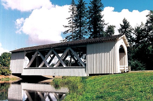
Local citizens worked through 1997 and 1998 to build a new covered bridge at the site.
This new bridge was dedicated in September 1998.


Take Salem exit 253 from I-5, head east on Highway 22 for 15 miles to the Stayton - Sublimity turnoff.
Travel south for one mile to Stayton.
Turn east on Marion Street to Pioneer Park.


Covered Bridge Information Courtesy of Covered Bridge Society of Oregon

Privacy < BACK  | HOME > Terms of Service
Contact OregonTravels.com
PO Box 1475
Medford, OR 97501
Office
541-499-4077
Email


Climb with an Accredited Guide Service


Orange Torpedo offers unique white water rafting trips on the Rogue, Salmon, Klamath and North Umpqua Rivers
Lake Creek Lodge
Seaside vacation Rentals
Flying Arrow Resort, Joseph Oregon


COVERED BRIDGES

EASTERN OREGON

MAPS & DIRECTIONS

OREGON ZIP CODES