HOME | Ashland | Bandon | Bend | Brookings | Cannon Beach | Coos Bay | Eugene | Depoe Bay | Florence | Gearhart | Gold Beach | Grants Pass | Hermiston | Jacksonville
Joseph | Klamath Falls | La Pine | Lincoln City | Manzanita | Medford | Newport | Portland | Port Orford | Rockaway | Roseburg | Salem | Seaside | Sisters | Yachats | ALL ...
HOTELS |  VACATION RENTALS |  RV PARKS |  B & B'S |  RESORTS |  WEATHER |  ROAD CAMS |  MAPS |  KAYAKING |  WINERIES |  RAFTING |  LIGHTHOUSES 
Mount St. Helens
Mount St. Helens VolcanoCam

Covered Bridges
:: Harris
:: Hayden
:: Irish Bend
:: Sandy Creek
:: Rock O' the Range
:: Cavitt Creek
:: Horse Creek
:: Milo Academy
:: Neal Lane
:: Pass Creek
:: Rochester
:: Antelope Creek
:: Lost Creek
:: McKee
:: Wimer
:: Grave Creek
:: Belknap
:: Centennial
:: Chambers
:: Coyote Creek
:: Currin
:: Deadwood
:: Dorena
:: Earnest
:: Goodpasture
:: Lake Creek
:: Lowell
:: Mosby Creek
:: Office (Westfir) Bridge
:: Parvin (Lost Creek) Bridge
:: Pengra (Fall Creek) Bridge
:: Stewart
:: Unity
:: Wendling
:: Wildcat Creek (Austa) Bridge
:: Chitwood
:: Drift Creek
:: Fisher School
:: North Fork Yachats
:: Crawfordsville
:: Gilkey
:: Hannah
:: Hoffman
:: Larwood
:: Shimanek
:: Short
:: Weddle
:: Gallon House
:: Stayton-Jordan
:: Cedar Crossing
:: Fourtner
:: Ritner

Weather Forecasts
:: Adams
:: Albany
:: Ashland
:: Astoria
:: Bandon
:: Bend
:: Brookings
:: Chiloquin
:: Dayton
:: Depoe Bay
:: Eugene
:: Florence
:: Fossil
:: Gold Beach
:: Government Camp
:: Glide
:: Hood River
:: Jacksonville
:: Joseph
:: Klamath Falls
:: Lincoln City
:: Mt. Hood
:: Newport
:: Pacific City
:: Paisley
:: Port Orford
:: Portland
:: Roseburg
:: Sunriver
:: Vida
:: Waldport
:: Yachats

Bookmark Us!

Newsletter Signup:


Oregon Covered Bridges - Fourtner, Polk County
<< Polk County Bridges << Covered Bridge Map All Covered Bridges >>


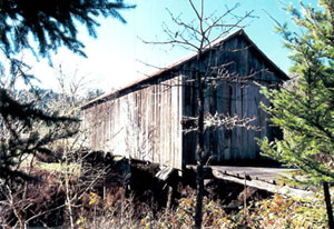
Built in 1932 by Doc and Lydia Fourtner to allow livestock to cross the South Yamhill River.
A sheet metal roof was added in later years and the bridge is currently in good condition overall.
The west end of the bridge is enclosed by a doorway allowing pedestrian access.


Take Highway 99 from Portland through Newberg to Highway 18.
West 60 miles past Willamina to New Grand Ronde.
North on Grand Ronde Road to "A" Ackerson Road. Turn left, continue one block, keep left at the "Y" in the road and into the yard of the white house.
Request permission to proceed at the house.


Covered Bridge Information Courtesy of Covered Bridge Society of Oregon

Privacy < BACK  | HOME > Terms of Service
Contact OregonTravels.com
PO Box 1475
Medford, OR 97501
Office
541-499-4077
Email


Climb with an Accredited Guide Service


Orange Torpedo offers unique white water rafting trips on the Rogue, Salmon, Klamath and North Umpqua Rivers
Lake Creek Lodge
Seaside vacation Rentals
Flying Arrow Resort, Joseph Oregon


COVERED BRIDGES

EASTERN OREGON

MAPS & DIRECTIONS

OREGON ZIP CODES