HOME | Ashland | Bandon | Bend | Brookings | Cannon Beach | Coos Bay | Eugene | Depoe Bay | Florence | Gearhart | Gold Beach | Grants Pass | Hermiston | Jacksonville
Joseph | Klamath Falls | La Pine | Lincoln City | Manzanita | Medford | Newport | Portland | Port Orford | Rockaway | Roseburg | Salem | Seaside | Sisters | Yachats | ALL ...
HOTELS |  VACATION RENTALS |  RV PARKS |  B & B'S |  RESORTS |  WEATHER |  ROAD CAMS |  MAPS |  KAYAKING |  WINERIES |  RAFTING |  LIGHTHOUSES 
Mount St. Helens
Mount St. Helens VolcanoCam

Covered Bridges
:: Harris
:: Hayden
:: Irish Bend
:: Sandy Creek
:: Rock O' the Range
:: Cavitt Creek
:: Horse Creek
:: Milo Academy
:: Neal Lane
:: Pass Creek
:: Rochester
:: Antelope Creek
:: Lost Creek
:: McKee
:: Wimer
:: Grave Creek
:: Belknap
:: Centennial
:: Chambers
:: Coyote Creek
:: Currin
:: Deadwood
:: Dorena
:: Earnest
:: Goodpasture
:: Lake Creek
:: Lowell
:: Mosby Creek
:: Office (Westfir) Bridge
:: Parvin (Lost Creek) Bridge
:: Pengra (Fall Creek) Bridge
:: Stewart
:: Unity
:: Wendling
:: Wildcat Creek (Austa) Bridge
:: Chitwood
:: Drift Creek
:: Fisher School
:: North Fork Yachats
:: Crawfordsville
:: Gilkey
:: Hannah
:: Hoffman
:: Larwood
:: Shimanek
:: Short
:: Weddle
:: Gallon House
:: Stayton-Jordan
:: Cedar Crossing
:: Fourtner
:: Ritner

Weather Forecasts
:: Adams
:: Albany
:: Ashland
:: Astoria
:: Bandon
:: Bend
:: Brookings
:: Chiloquin
:: Dayton
:: Depoe Bay
:: Eugene
:: Florence
:: Fossil
:: Gold Beach
:: Government Camp
:: Glide
:: Hood River
:: Jacksonville
:: Joseph
:: Klamath Falls
:: Lincoln City
:: Mt. Hood
:: Newport
:: Pacific City
:: Paisley
:: Port Orford
:: Portland
:: Roseburg
:: Sunriver
:: Vida
:: Waldport
:: Yachats

Bookmark Us!

Newsletter Signup:


Row River (Currin) Covered Bridge, Lane County, Oregon
<< Lane County Bridges << Covered Bridge Map All Covered Bridges >>


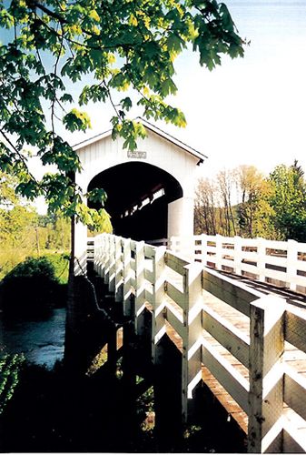
The Currin Bridge was named after an early pioneer family in the area.
Nels Roney constructed the first covered bridge at this site in 1883 for $1,935 and was replaced in 1925 at a cost of $4,025.
Architectural highlights include single piece hand-hewn chords and cross-wise planking on the approach.
Lane County closed the bridge to traffic when it was bypassed by a concrete span.
In late 1987, the bridge was mothballed by removing an approach and placing a wire fence in the portal.
During the 1993-95 Oregon Covered Bridge Program, Lane County received a $48,000 grant to rehabilitate and re-open the bridge to pedestrian traffic. Work items included truss repairs, a new rail system, a new synthetic roof, repaired siding and house painting.


Go four miles southeast of Cottage Grove on Row River Road to the intersection of Layng Road.
The bridge crosses the Row River at this location and is located one mile from the Mosby Creek Bridge, which is also on Layng Road.


Covered Bridge Information Courtesy of Covered Bridge Society of Oregon

Privacy < BACK  | HOME > Terms of Service
Contact OregonTravels.com
PO Box 1475
Medford, OR 97501
Office
541-499-4077
Email


Climb with an Accredited Guide Service


Orange Torpedo offers unique white water rafting trips on the Rogue, Salmon, Klamath and North Umpqua Rivers
Lake Creek Lodge
Seaside vacation Rentals
Flying Arrow Resort, Joseph Oregon


COVERED BRIDGES

EASTERN OREGON

MAPS & DIRECTIONS

OREGON ZIP CODES