HOME | Ashland | Bandon | Bend | Brookings | Cannon Beach | Coos Bay | Eugene | Depoe Bay | Florence | Gearhart | Gold Beach | Grants Pass | Hermiston | Jacksonville
Joseph | Klamath Falls | La Pine | Lincoln City | Manzanita | Medford | Newport | Portland | Port Orford | Rockaway | Roseburg | Salem | Seaside | Sisters | Yachats | ALL ...
HOTELS |  VACATION RENTALS |  RV PARKS |  B & B'S |  RESORTS |  WEATHER |  ROAD CAMS |  MAPS |  KAYAKING |  WINERIES |  RAFTING |  LIGHTHOUSES 
Mount St. Helens
Mount St. Helens VolcanoCam

Covered Bridges
:: Harris
:: Hayden
:: Irish Bend
:: Sandy Creek
:: Rock O' the Range
:: Cavitt Creek
:: Horse Creek
:: Milo Academy
:: Neal Lane
:: Pass Creek
:: Rochester
:: Antelope Creek
:: Lost Creek
:: McKee
:: Wimer
:: Grave Creek
:: Belknap
:: Centennial
:: Chambers
:: Coyote Creek
:: Currin
:: Deadwood
:: Dorena
:: Earnest
:: Goodpasture
:: Lake Creek
:: Lowell
:: Mosby Creek
:: Office (Westfir) Bridge
:: Parvin (Lost Creek) Bridge
:: Pengra (Fall Creek) Bridge
:: Stewart
:: Unity
:: Wendling
:: Wildcat Creek (Austa) Bridge
:: Chitwood
:: Drift Creek
:: Fisher School
:: North Fork Yachats
:: Crawfordsville
:: Gilkey
:: Hannah
:: Hoffman
:: Larwood
:: Shimanek
:: Short
:: Weddle
:: Gallon House
:: Stayton-Jordan
:: Cedar Crossing
:: Fourtner
:: Ritner

Weather Forecasts
:: Adams
:: Albany
:: Ashland
:: Astoria
:: Bandon
:: Bend
:: Brookings
:: Chiloquin
:: Dayton
:: Depoe Bay
:: Eugene
:: Florence
:: Fossil
:: Gold Beach
:: Government Camp
:: Glide
:: Hood River
:: Jacksonville
:: Joseph
:: Klamath Falls
:: Lincoln City
:: Mt. Hood
:: Newport
:: Pacific City
:: Paisley
:: Port Orford
:: Portland
:: Roseburg
:: Sunriver
:: Vida
:: Waldport
:: Yachats

Bookmark Us!

Newsletter Signup:


North Fork of the Middle Fork Willamette River (Office) Covered Bridge,
Lane County, Oregon
<< Lane County Bridges << Covered Bridge Map All Covered Bridges >>


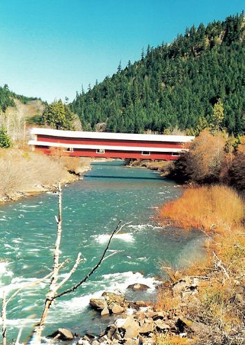
The Office Covered Bridge was built in 1944 by the Westfir Lumber Company and spans the North Fork of the Middle Fork of the Willamette River at the town of Westfir. It is Oregon’s longest covered span at 180 feet.
The wooden span was constructed for logging trucks and connected a lumber mill and its office, hence the name.
In the early 1980s the mill burned and the bridge was closed to traffic.
In 1992 the bridge became the property of Lane County through tax foreclosure.
Extensive repair work in 1992 stabilized the bridge condition, and in 2002, a new roof was added.
A distinctive feature of the span is the covered walkway separate from the roadway. Because the bridge was built for carrying loaded log trucks, the truss members are gigantic with multiple tension rods and compound chord members. The house has horizontal shiplap siding.


From Interstate 5 take Highway 58 east towards Oakridge.
Just before entering Oakridge, near milepost 31, turn west onto Westridge Ave. Continue to Westfir on County Road 6128.
Travel about 2.5 miles to the mill site, community and bridge.


Covered Bridge Information Courtesy of Covered Bridge Society of Oregon

Privacy < BACK  | HOME > Terms of Service
Contact OregonTravels.com
PO Box 1475
Medford, OR 97501
Office
541-499-4077
Email


Climb with an Accredited Guide Service


Orange Torpedo offers unique white water rafting trips on the Rogue, Salmon, Klamath and North Umpqua Rivers
Lake Creek Lodge
Seaside vacation Rentals
Flying Arrow Resort, Joseph Oregon


COVERED BRIDGES

EASTERN OREGON

MAPS & DIRECTIONS

OREGON ZIP CODES