HOME | Ashland | Bandon | Bend | Brookings | Cannon Beach | Coos Bay | Eugene | Depoe Bay | Florence | Gearhart | Gold Beach | Grants Pass | Hermiston | Jacksonville
Joseph | Klamath Falls | La Pine | Lincoln City | Manzanita | Medford | Newport | Portland | Port Orford | Rockaway | Roseburg | Salem | Seaside | Sisters | Yachats | ALL ...
HOTELS |  VACATION RENTALS |  RV PARKS |  B & B'S |  RESORTS |  WEATHER |  ROAD CAMS |  MAPS |  KAYAKING |  WINERIES |  RAFTING |  LIGHTHOUSES 
Mount St. Helens
Mount St. Helens VolcanoCam

Covered Bridges
:: Harris
:: Hayden
:: Irish Bend
:: Sandy Creek
:: Rock O' the Range
:: Cavitt Creek
:: Horse Creek
:: Milo Academy
:: Neal Lane
:: Pass Creek
:: Rochester
:: Antelope Creek
:: Lost Creek
:: McKee
:: Wimer
:: Grave Creek
:: Belknap
:: Centennial
:: Chambers
:: Coyote Creek
:: Currin
:: Deadwood
:: Dorena
:: Earnest
:: Goodpasture
:: Lake Creek
:: Lowell
:: Mosby Creek
:: Office (Westfir) Bridge
:: Parvin (Lost Creek) Bridge
:: Pengra (Fall Creek) Bridge
:: Stewart
:: Unity
:: Wendling
:: Wildcat Creek (Austa) Bridge
:: Chitwood
:: Drift Creek
:: Fisher School
:: North Fork Yachats
:: Crawfordsville
:: Gilkey
:: Hannah
:: Hoffman
:: Larwood
:: Shimanek
:: Short
:: Weddle
:: Gallon House
:: Stayton-Jordan
:: Cedar Crossing
:: Fourtner
:: Ritner

Weather Forecasts
:: Adams
:: Albany
:: Ashland
:: Astoria
:: Bandon
:: Bend
:: Brookings
:: Chiloquin
:: Dayton
:: Depoe Bay
:: Eugene
:: Florence
:: Fossil
:: Gold Beach
:: Government Camp
:: Glide
:: Hood River
:: Jacksonville
:: Joseph
:: Klamath Falls
:: Lincoln City
:: Mt. Hood
:: Newport
:: Pacific City
:: Paisley
:: Port Orford
:: Portland
:: Roseburg
:: Sunriver
:: Vida
:: Waldport
:: Yachats

Bookmark Us!

Newsletter Signup:


Fall Creek (Pengra) Covered Bridge, Lane County, Oregon
<< Lane County Bridges << Covered Bridge Map All Covered Bridges >>


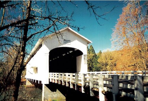
The Pengra Bridge contains two of the longest timbers ever cut for a bridge in Oregon. The timbers for the lower chords, 16" x 18" x 126 feet, were cut by the Booth-Kelly Lumber Company east of Springfield.
Since 18" timbers were too large to be run through a mill, they were rough-hewn in the woods, transported to the bridge site by truck and resurfaced before being set into place.
The dimensions of the upper chord are similar proportions at 14" x 18" x 96 feet.
The use of one-piece chords simplified construction techniques and resulted in a stronger truss, but handling such large timbers was often difficult.
The Pengra Bridge replaced a 192-foot span built in 1904 which had been only a few feet upstream from the present structure.
The effect of weather and increased traffic caused the county to close the bridge in 1979.
County officials had planned to reopen the structure, but readying a contract for work was delayed for several years.
The bridge was repaired and re-opened to traffic by the county in 1995 with the help of a grant from the Oregon Covered Bridge Program.
Pengra was a station on the Cascade Line of the Southern Pacific Railroad and was named for B. J. Pengra, a pioneer who became general surveyor of Oregon in 1862.
Pengra had surveyed the route of the Oregon Central Military Road to link the Willamette Valley with the Owyhee mining country of Eastern Oregon.
The road was finished to the summit of the Cascades in 1867 but was seldom used. The Pengra Unity Road lies on the old railroad grade and has been renamed Place Road.


From I-5 take Highway 58 east to Parkway Road.
Follow Parkway Road north to the community of Jasper.
Turn southeast on Jasper-Lowell Road for about 3 miles.
Turn left on Little Falls Creek Road and travel 1/4 mile to Place Road.


Covered Bridge Information Courtesy of Covered Bridge Society of Oregon

Privacy < BACK  | HOME > Terms of Service
Contact OregonTravels.com
PO Box 1475
Medford, OR 97501
Office
541-499-4077
Email


Climb with an Accredited Guide Service


Orange Torpedo offers unique white water rafting trips on the Rogue, Salmon, Klamath and North Umpqua Rivers
Lake Creek Lodge
Seaside vacation Rentals
Flying Arrow Resort, Joseph Oregon


COVERED BRIDGES

EASTERN OREGON

MAPS & DIRECTIONS

OREGON ZIP CODES